APKPure で安全で高速な APK のダウンロード
APKPure は署名検証を使用して、ウイルスフリーの シンガポールMRT:地図と経路(Pro) MRT Map APK ダウンロードを保証します。
シンガポールMRTの最速ルートと所要時間を確認。地図付き
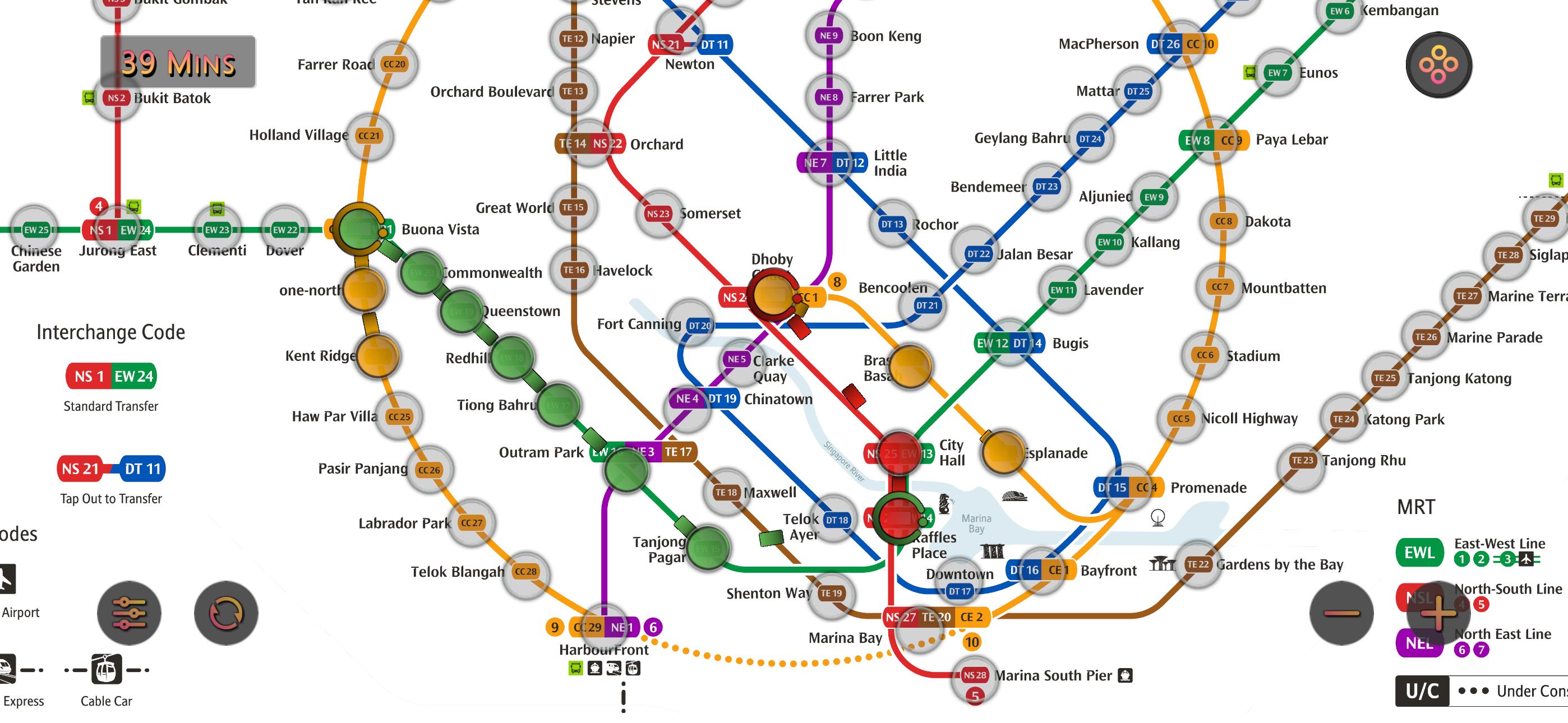
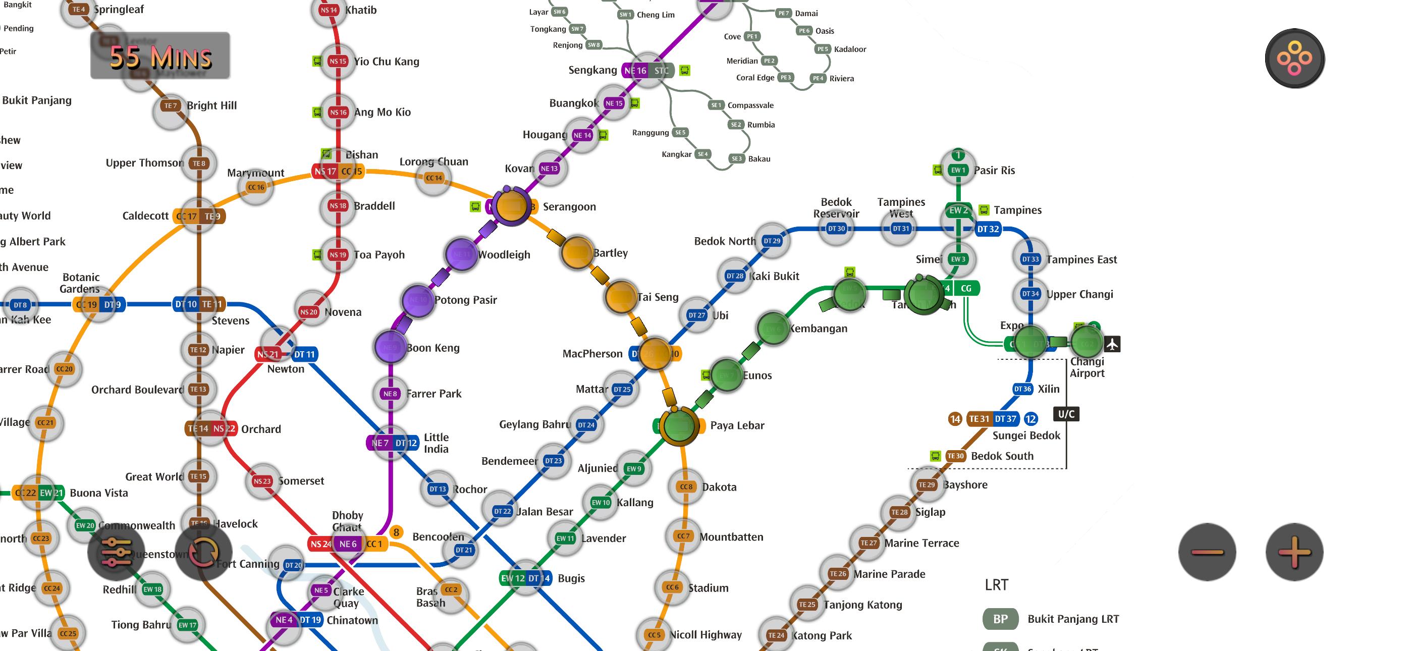
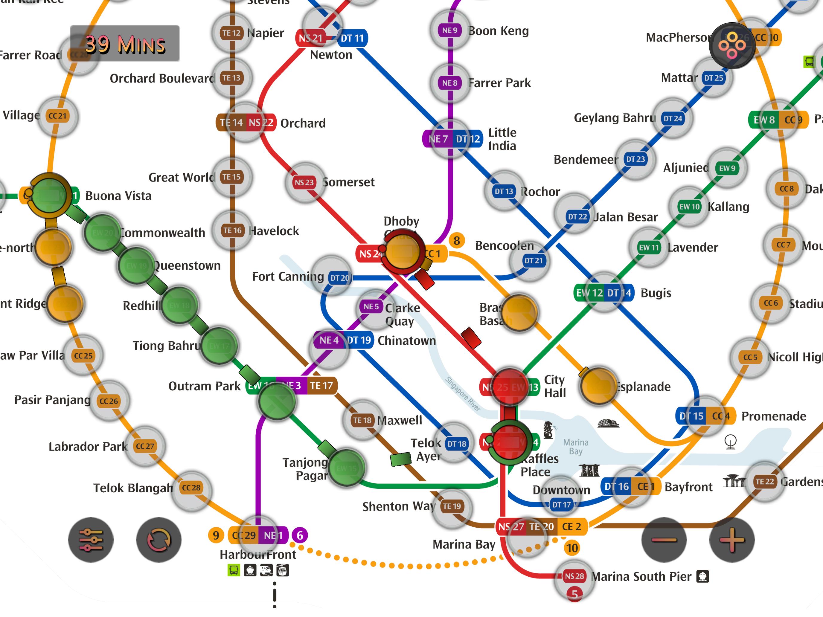
シンガポールMRT:地図と経路 は、ユーザーが最適なルートを1秒で取得できるように設計されています。
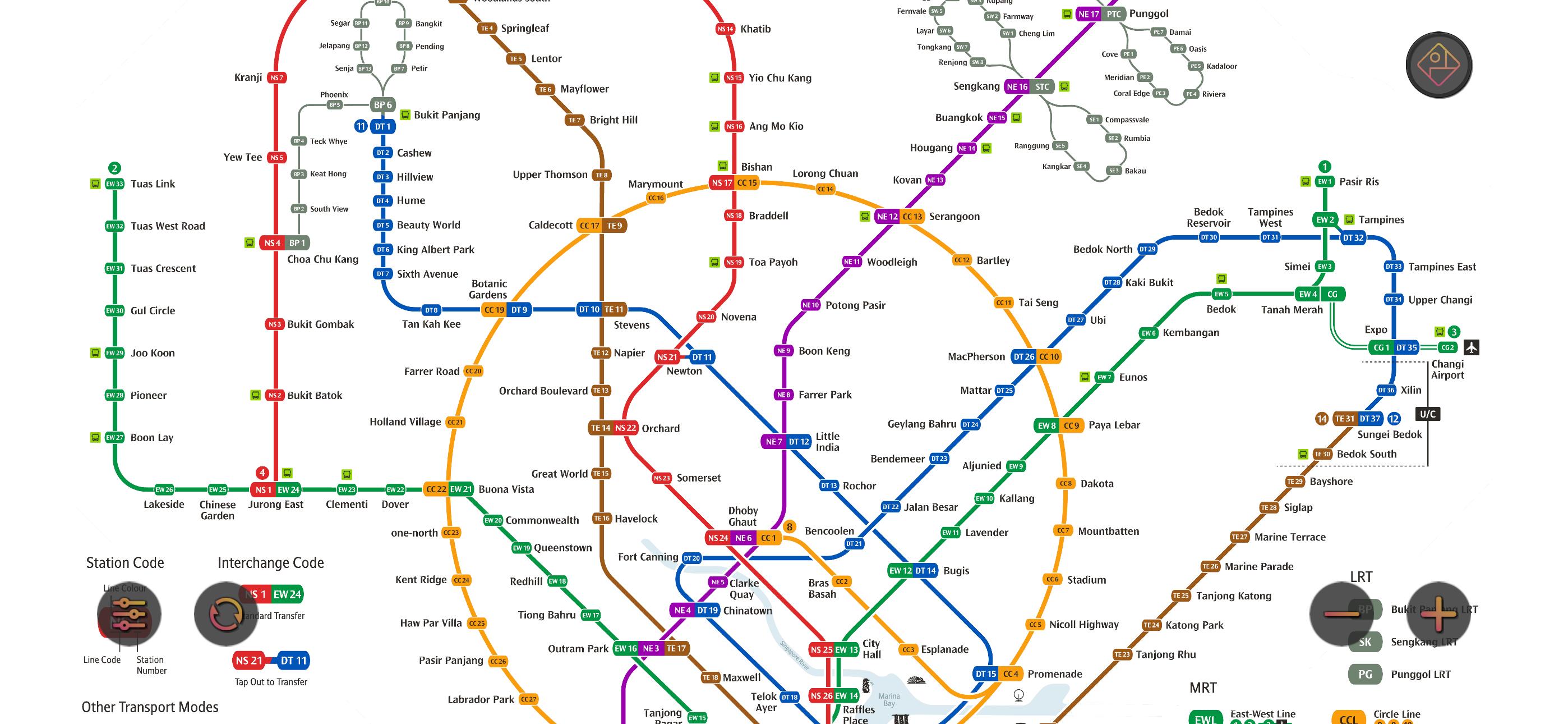
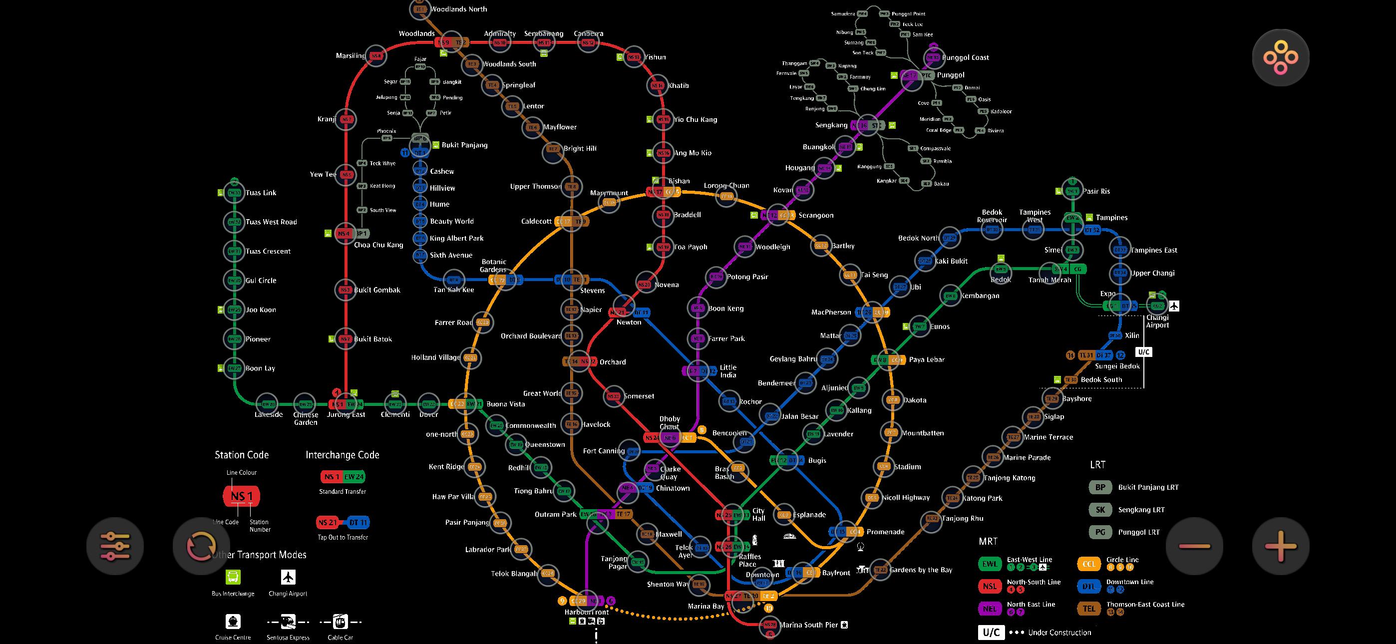
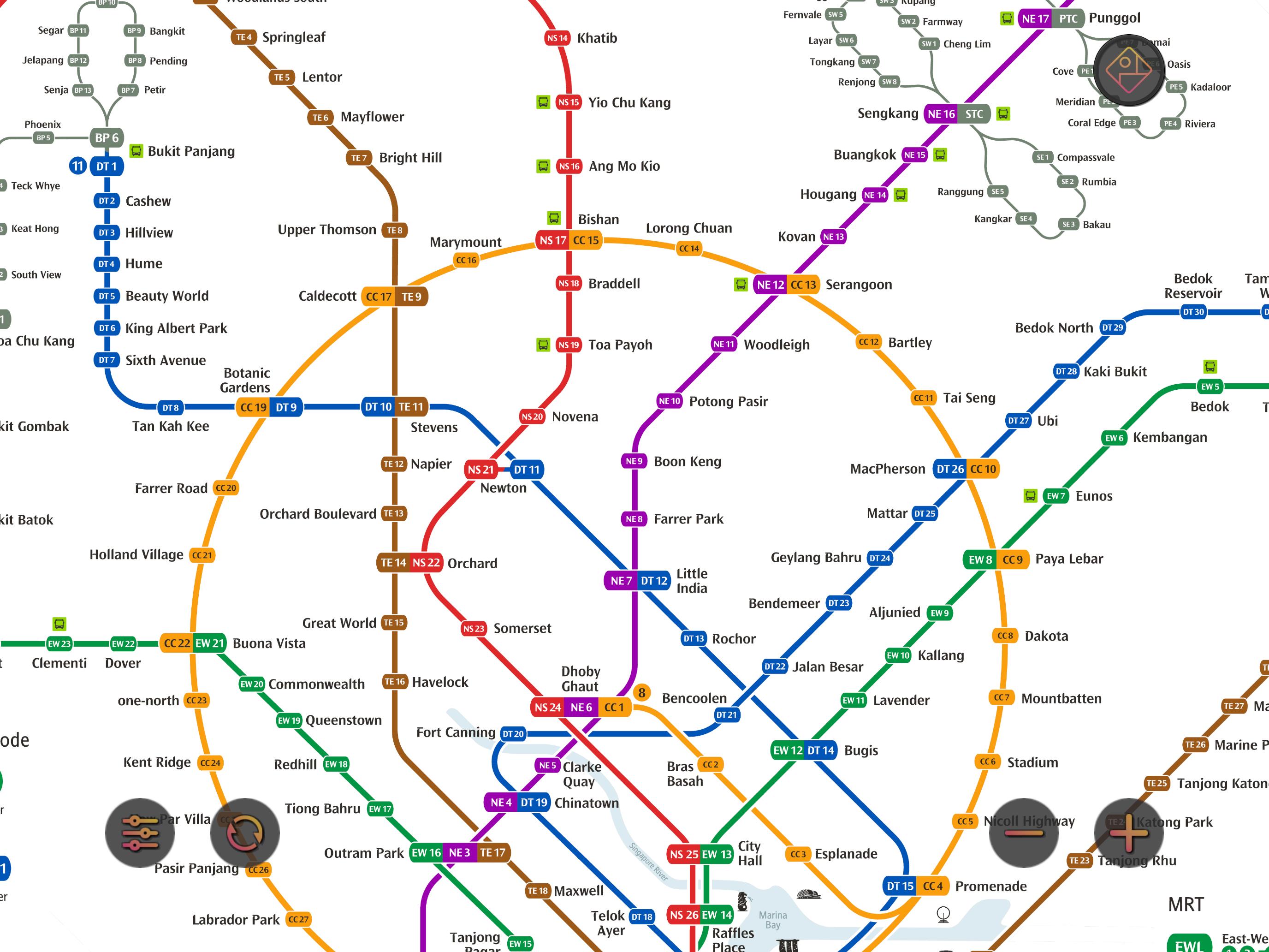
最新の地下鉄マップを表示
2駅間の最適ルートを計算
推定所要時間を表示
最新の地下鉄システムに更新済み:
North-South Line (NSL)
Jurong East, Bukit Batok, Bukit Gombak, Choa Chu Kang, Yew Tee, Kranji, Marsiling, Woodlands, Admiralty, Sembawang, Canberra, Yishun, Khatib, Yio Chu Kang, Ang Mo Kio, Bishan, Braddell, Toa Payoh, Novena, Newton, Orchard, Somerset, Dhoby Ghaut, City Hall, Raffles Place, Marina Bay, Marina South Pier
East-West Line (EWL)
Tuas Link, Tuas West Road, Tuas Crescent, Gul Circle, Joo Koon, Pioneer, Boon Lay, Lakeside, Chinese Garden, Jurong East, Clementi, Dover, Buona Vista, Commonwealth, Queenstown, Redhill, Tiong Bahru, Outram Park, Tanjong Pagar, Raffles Place, City Hall, Bugis, Lavender, Kallang, Aljunied, Paya Lebar, Eunos, Kembangan, Bedok, Tanah Merah, Simei, Tampines, Pasir Ris
(Changi Airport Branch from Tanah Merah)
Expo, Changi Airport
North East Line (NEL)
HarbourFront, Outram Park, Chinatown, Clarke Quay, Dhoby Ghaut, Little India, Farrer Park, Boon Keng, Potong Pasir, Woodleigh, Serangoon, Kovan, Hougang, Buangkok, Sengkang, Punggol
Circle Line (CCL)
Dhoby Ghaut, Bras Basah, Esplanade, Promenade, Nicoll Highway, Stadium, Mountbatten, Dakota, Paya Lebar, MacPherson, Tai Seng, Bartley, Serangoon, Lorong Chuan, Bishan, Marymount, Caldecott, Botanic Gardens, Farrer Road, Holland Village, Buona Vista, one-north, Kent Ridge, Haw Par Villa, Pasir Panjang, Labrador Park, Telok Blangah, HarbourFront
(Marina Bay Branch from Promenade)
Bayfront, Marina Bay
Downtown Line (DTL)
Bukit Panjang, Cashew, Hillview, Beauty World, King Albert Park, Sixth Avenue, Tan Kah Kee, Botanic Gardens, Stevens, Newton, Little India, Rochor, Bugis, Promenade, Bayfront, Downtown, Telok Ayer, Chinatown, Fort Canning, Bencoolen, Jalan Besar, Bendemeer, Geylang Bahru, Mattar, MacPherson, Ubi, Kaki Bukit, Bedok North, Bedok Reservoir, Tampines West, Tampines, Tampines East, Upper Changi, Expo
Thomson-East Coast Line (TEL)
Woodlands North, Woodlands, Woodlands South, Springleaf, Lentor, Mayflower, Bright Hill, Upper Thomson, Caldecott, Stevens, Napier, Orchard Boulevard, Orchard, Great World, Havelock, Outram Park, Maxwell, Shenton Way, Marina Bay, Marina South, Gardens by the Bay


あなたの評価とフィードバックをありがとう!
すでに評価しました。