ดาวน์โหลด APK ได้อย่างปลอดภัยและรวดเร็วบน APKPure
APKPure ใช้การตรวจสอบลายเซ็นเพื่อประกันการดาวน์โหลด APK ของ Singapore MRT Map Route(Pro) ที่ปลอดไวรัสสำหรับคุณ
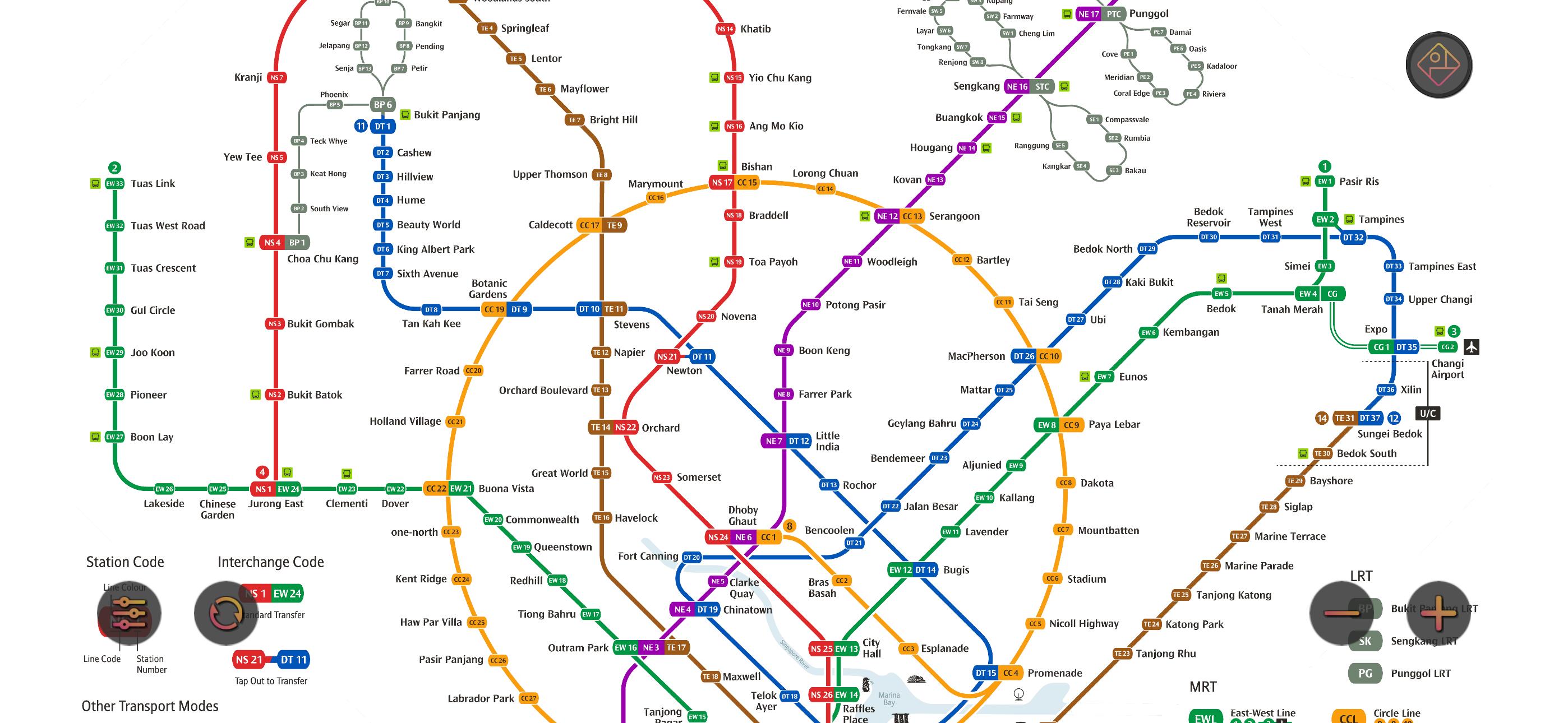
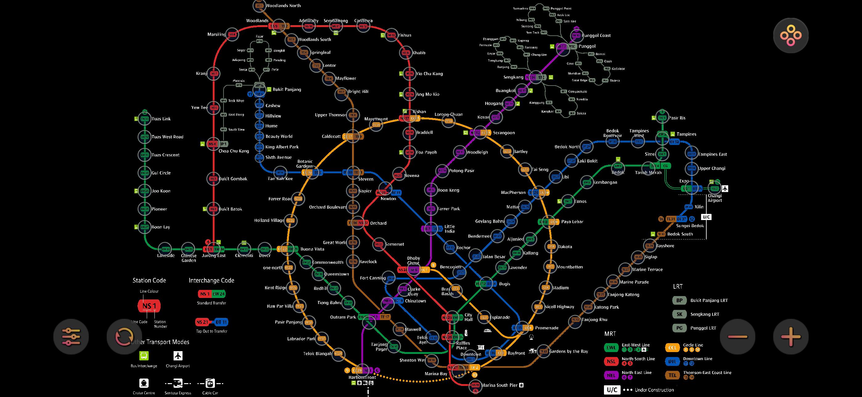
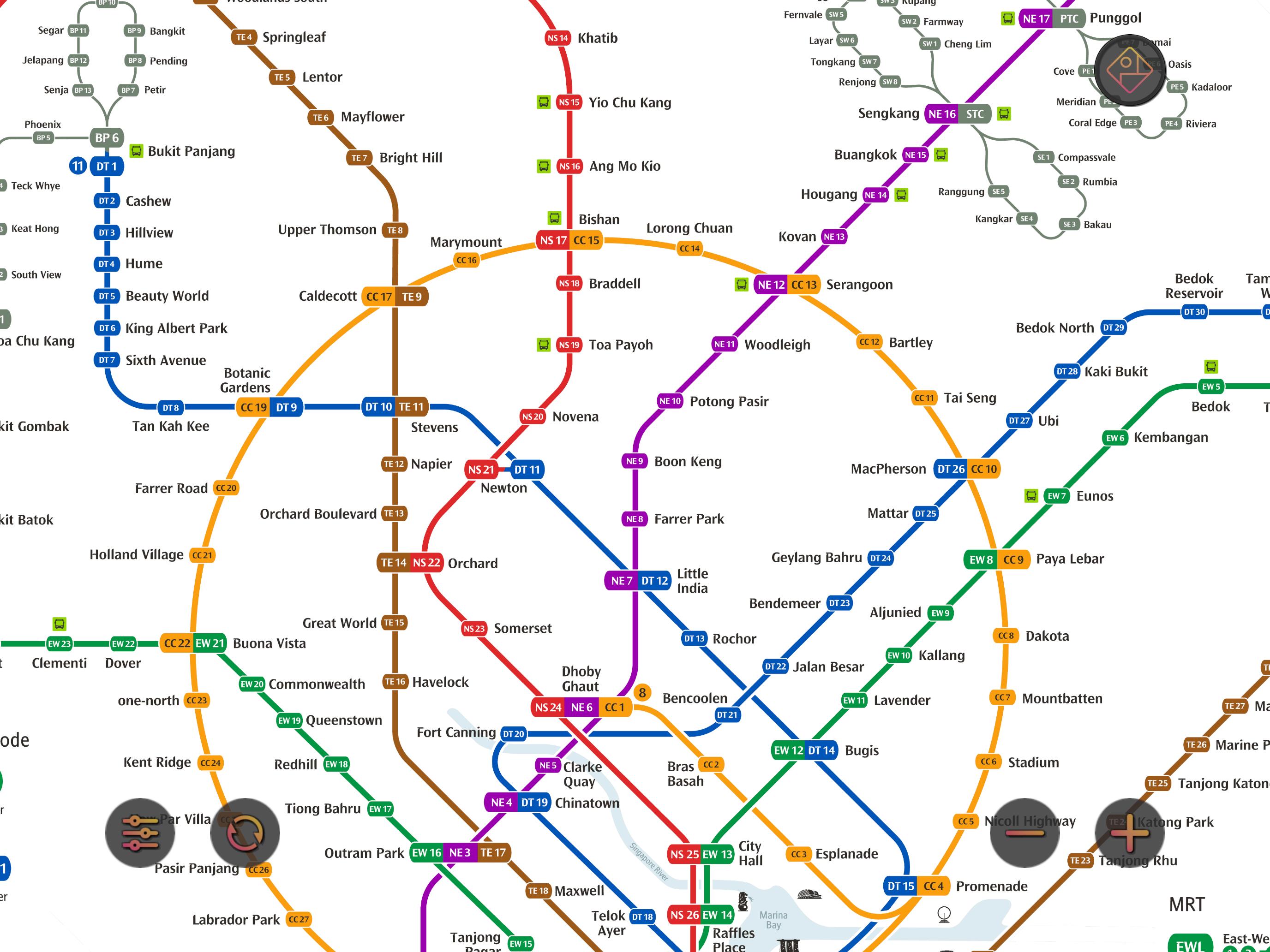
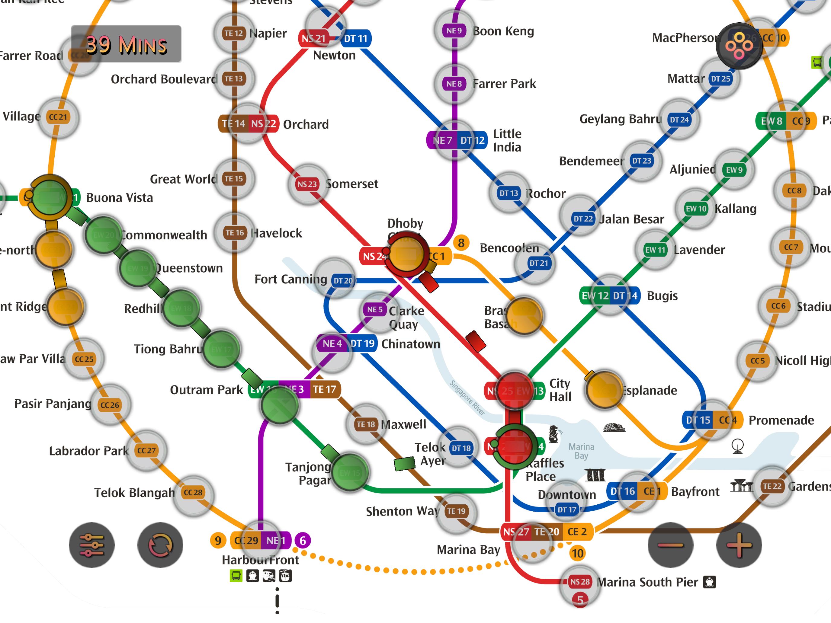
ดูเส้นทางและเวลาที่เร็วที่สุดของ MRT สิงคโปร์ พร้อมแผนที่รถไฟ
Singapore MRT Map Route ได้รับการออกแบบมาเพื่อให้ผู้ใช้สามารถค้นหาเส้นทางที่ดีที่สุดได้ภายในหนึ่งวินาที
ดูแผนที่รถไฟฟ้าล่าสุด
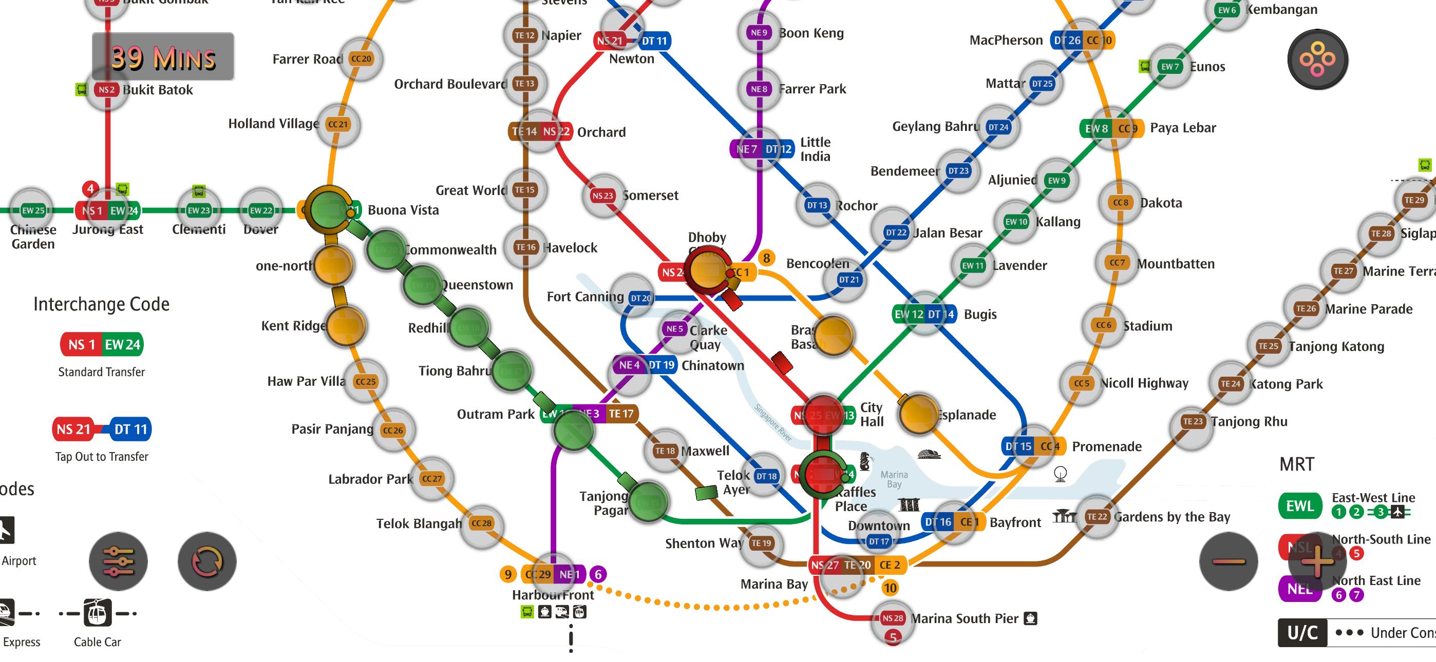
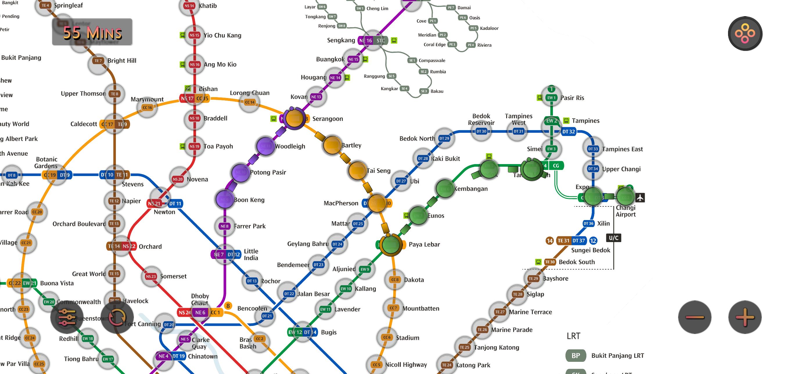
คำนวณเส้นทางที่ดีที่สุดระหว่างสองสถานี
แสดงเวลาการเดินทางโดยประมาณ
อัปเดตตามระบบรถไฟฟ้าล่าสุด:
North-South Line (NSL)
Jurong East, Bukit Batok, Bukit Gombak, Choa Chu Kang, Yew Tee, Kranji, Marsiling, Woodlands, Admiralty, Sembawang, Canberra, Yishun, Khatib, Yio Chu Kang, Ang Mo Kio, Bishan, Braddell, Toa Payoh, Novena, Newton, Orchard, Somerset, Dhoby Ghaut, City Hall, Raffles Place, Marina Bay, Marina South Pier
East-West Line (EWL)
Tuas Link, Tuas West Road, Tuas Crescent, Gul Circle, Joo Koon, Pioneer, Boon Lay, Lakeside, Chinese Garden, Jurong East, Clementi, Dover, Buona Vista, Commonwealth, Queenstown, Redhill, Tiong Bahru, Outram Park, Tanjong Pagar, Raffles Place, City Hall, Bugis, Lavender, Kallang, Aljunied, Paya Lebar, Eunos, Kembangan, Bedok, Tanah Merah, Simei, Tampines, Pasir Ris
(Changi Airport Branch from Tanah Merah)
Expo, Changi Airport
North East Line (NEL)
HarbourFront, Outram Park, Chinatown, Clarke Quay, Dhoby Ghaut, Little India, Farrer Park, Boon Keng, Potong Pasir, Woodleigh, Serangoon, Kovan, Hougang, Buangkok, Sengkang, Punggol
Circle Line (CCL)
Dhoby Ghaut, Bras Basah, Esplanade, Promenade, Nicoll Highway, Stadium, Mountbatten, Dakota, Paya Lebar, MacPherson, Tai Seng, Bartley, Serangoon, Lorong Chuan, Bishan, Marymount, Caldecott, Botanic Gardens, Farrer Road, Holland Village, Buona Vista, one-north, Kent Ridge, Haw Par Villa, Pasir Panjang, Labrador Park, Telok Blangah, HarbourFront
(Marina Bay Branch from Promenade)
Bayfront, Marina Bay
Downtown Line (DTL)
Bukit Panjang, Cashew, Hillview, Beauty World, King Albert Park, Sixth Avenue, Tan Kah Kee, Botanic Gardens, Stevens, Newton, Little India, Rochor, Bugis, Promenade, Bayfront, Downtown, Telok Ayer, Chinatown, Fort Canning, Bencoolen, Jalan Besar, Bendemeer, Geylang Bahru, Mattar, MacPherson, Ubi, Kaki Bukit, Bedok North, Bedok Reservoir, Tampines West, Tampines, Tampines East, Upper Changi, Expo
Thomson-East Coast Line (TEL)
Woodlands North, Woodlands, Woodlands South, Springleaf, Lentor, Mayflower, Bright Hill, Upper Thomson, Caldecott, Stevens, Napier, Orchard Boulevard, Orchard, Great World, Havelock, Outram Park, Maxwell, Shenton Way, Marina Bay, Marina South, Gardens by the Bay


คลิกเพียงครั้งเดียวเพื่อติดตั้งไฟล์ XAPK/APK บน Android!
ขอบคุณสำหรับการให้คะแนนและข้อเสนอแนะของคุณ!
คุณได้ให้คะแนนแล้ว