APKPure에서 안전하고 빠른 APK 다운로드
APKPure는 바이러스 없는 Welsh Hills Terrain APK 다운로드를 위해 서명 확인을 사용합니다.
Enjoy millions of the latest Android apps, games, music, movies, TV, books, magazines & more. Anytime, anywhere, across your devices.
Features of Free version:
Display an augmented reality (AR) topographic terrain view from the top of over 900 hills and mountains of Wales based on the hill data database maintained at 'http://www.hills-database.co.uk'.
Browse and display individual hills details, then select the annotated 3-D panoramic view option to create a representation of the 3-D surrounding topographic terrain (up to 30Km) with visible hills labelled. The panoramic display can be automatically updated via the device sensors to provide an augmented reality (AR) overlay view of the surrounding terrain in conjunction with the rear camera.
Simply point your device and the terrain is displayed and the visible hills are labelled on the terrain view. Other similar apps only account for the line-of-sight hill direction without considering the actual terrain between your viewpoint and a hill location, where nearer hills tend to obscure further away hills, irrespective of height. This app calculates the hills that are actually visible based on location and surrounding terrain.
Does not require an Internet connection to display terrain view (since you're not likely to have one at the top of a hill), all hill / terrain data is stored within the app.
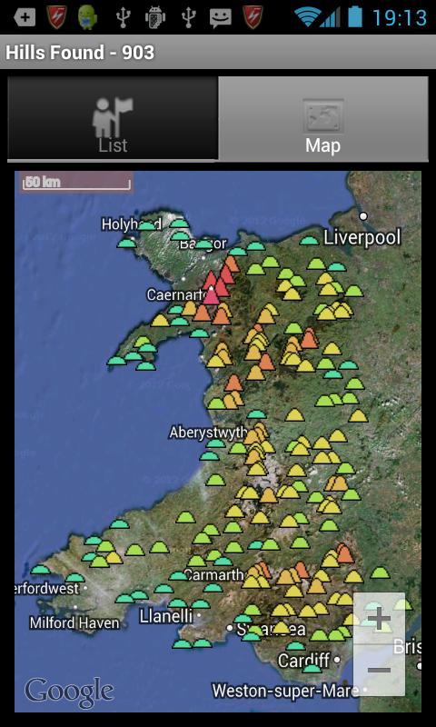
The list of hills can be browsed manually, searched by name and filtered based on hill-type e.g. Marilyn etc. The filtered hills can also be displayed on a scaled map view (requires Internet connection), that allows for adaptive zooming i.e. more hills are shown as you zoom in.
Features of PRO (paid) version:
There is a GPS option to determine your current location automatically and display the surrounding annotated 3-D view anywhere within Wales, not just hilltops. A preview of the nearby hills is also displayed on a scaled 'radar-view' that rotates with the device.
This version also allows for locations to be entered manually based on either grid reference or latitude/longitude and display the surrounding annotated 3-D view anywhere within Wales, not just hilltops. A preview of the nearby hills is also display on a scaled 'radar-view' that rotates with the device. There is also the ability to use the map-view to select any location within Wales and display the surrounding annotated 3-D view.
The PRO version allows for a 'pinch-zoom' facility on the 3-D panoramic view (if supported by device camera).
Note: Requires 'Google Play Services' App
General minor bug fixes.
Add support for storing hill filter options between sessions / screens.
Add map background switch button.
Add basic button support for reading / displaying GPX / KML files on map view.


등급과 피드백에 감사드립니다!
당신은 이미 평가했습니다.