Marine Ways - Nautical Charts

Marine Ways - Nautical Charts

Kernalite
Feb 19, 2025
  • 9.5 MB

    File Size

  • Android 8.0+

    Android OS

About Marine Ways - Nautical Charts

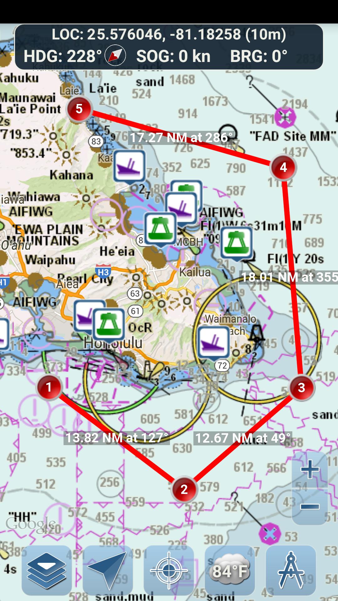
Nautical charts, route planning, and GPS-guided marine navigation

This application is not affiliated with NOAA and does not represent any government entity.

This app uses freely available charts from NOAA and other sources listed below.

https://charts.noaa.gov/ENCs/ENCs.shtml

https://www.linz.govt.nz/

https://www.weather.gov/

Navigational Charts Disclaimer from NOAA:

NOAA ENC Online is not certified for navigation. Screen captures of the ENCs displayed here do NOT fulfill chart carriage requirements for regulated commercial vessels under Titles 33 and 46 of the Code of Federal Regulations.

Marine Ways Boating is the ultimate marine navigation and planning application! In this application you will gain access to:

NAVIGATIONAL CHARTS

- United States charts provided by National Oceanic and Atmospheric Administration (NOAA)

https://charts.noaa.gov/ENCs/ENCs.shtml

- New Zealand charts provided by Land Information New Zealand (LINZ)

https://www.linz.govt.nz/

Chart types:

- NOAA Electronic Navigational Charts (ENC) (NOAA's newest and most powerful electronic charting product).

https://charts.noaa.gov/ENCs/ENCs.shtml

https://nauticalcharts.noaa.gov/

- NOAA classic charts (including Day, Red, Dusk, Night, and Gray versions).

- LINZ charts (available in Day, Dusk, and Night versions only currently)

https://www.linz.govt.nz/

ROUTE PLANNING TOOLS

-Route Plotting. Tap and hold on the map for one second to plot your waypoints. To form a route, continue to tap and hold on the map in different areas. Distance and bearing are conveniently calculated and displayed for each leg as you add, adjust, or remove waypoints.

-Travel Mode. Automatically centers the map on your current position as you move. Use travel mode to see how closely you are following your plotted route in real time!

-Route Leg Summary. A convenient view containing detailed information of each leg you have plotted, including start and end coordinates, distance, and bearing.

BUOY REPORTS AND OBSTRUCTION INFORMATION

Data obtained from: https://www.weather.gov/

Markers for buoys and obstructions are conveniently plotted in their actual location on the map! Just click on the marker to view their information!

- Buoy Reports: Get complete current conditions and wave reports for fixed and drifting buoys.

https://www.weather.gov/

- Obstructions: Get location and history information about potentially dangerous, submerged hazards including rocks and sunken vessels.

https://www.weather.gov/

MARINE MAP OVERLAYS

Toggle various marine overlay data right onto the map to get a better idea of the current boating conditions!

Overlays include:

- Water Surface Temperature (Global)

- Wind Speeds (US only)

- Wind Gusts (US only)

- Wave Heights (US only)

https://www.weather.gov/

LOCATION SHARING OVER WATER / VIEW OTHER BOATS

- Display your last known location, speed, bearing, and boat name on the map for other Marine Ways boaters to view.

- View the last known location, speed, bearing, and boat name of other Marine Ways boaters, as well as their distance and bearing from your location.

- Location sharing is turned off by default. When you are ready to share, toggle it on within general settings. To continuously update your location on the map, keep the app opened and focused. The app currently does not update your location in the background.

WEATHER INFORMATION

- Weather Precipitation Radar (US & Hawaii only). Detects any rain and snow in the area.

- Weather Station. Reports the nearest observation station data. Current temperature, humidity, weather conditions, wind, and more! Station observation data is available globally.

- Land Surface Temperature overlay. Shows the current surface temperature on land (US only).

Before using this application, please read and agree to the following terms of use / service and privacy policy:

Terms of Use / Service: http://www.marineways.com/appterms

Privacy policy: http://www.marineways.com/appprivacy

Enjoy the app! Marine Ways is also available on the web at http://www.marineways.com

Show More

What's new in the latest 1.68

Last updated on 2025-02-19
Bug fixes and performance improvements.
Show More

Videos and Screenshots

  • Marine Ways - Nautical Charts poster
  • Marine Ways - Nautical Charts screenshot 1
  • Marine Ways - Nautical Charts screenshot 2
  • Marine Ways - Nautical Charts screenshot 3
  • Marine Ways - Nautical Charts screenshot 4
  • Marine Ways - Nautical Charts screenshot 5
  • Marine Ways - Nautical Charts screenshot 6
  • Marine Ways - Nautical Charts screenshot 7

Marine Ways - Nautical Charts APK Information

Latest Version
1.68
Android OS
Android 8.0+
File Size
9.5 MB
Developer
Kernalite
Available on
Safe & Fast APK Downloads on APKPure
APKPure uses signature verification to ensure virus-free Marine Ways - Nautical Charts APK downloads for you.
APKPure icon

Super Fast and Safe Downloading via APKPure App

One-click to install XAPK/APK files on Android!

Download APKPure
thank icon
We use cookies and other technologies on this website to enhance your user experience.
By clicking any link on this page you are giving your consent to our Privacy Policy and Cookies Policy.
Learn More about Policies