Safe & Fast APK Downloads on APKPure
APKPure uses signature verification to ensure virus-free Landsnap: Search Land Records APK downloads for you.
Effortlessly search Telangana & Andhra Pradesh land details with Landsnap
**Landsnap – Search Andhra Pradesh & Telangana Land Records Easily**
> 📢 **Disclaimer:** *This app is not an official government application and is not affiliated with the Government of Telangana or Andhra Pradesh. Landsnap provides information sourced from public government portals for user convenience only. Always verify land records directly on the official sites.*
---
**Landsnap** is your go-to app for quick and easy access to **Andhra Pradesh (Mee Bhoomi)** and **Telangana (Bhu Bharati)** land records. Designed for both professionals and the general public, the app streamlines the process of checking **ROR-1B**, **Pahani**, **FMB maps**, and more, all from your phone.
**📌 Data Sources:**
• Telangana: [https://bhubharati.telangana.gov.in](https://bhubharati.telangana.gov.in)
• Andhra Pradesh: [https://meebhoomi.ap.gov.in](https://meebhoomi.ap.gov.in)
---
### 🔍 Key Features:
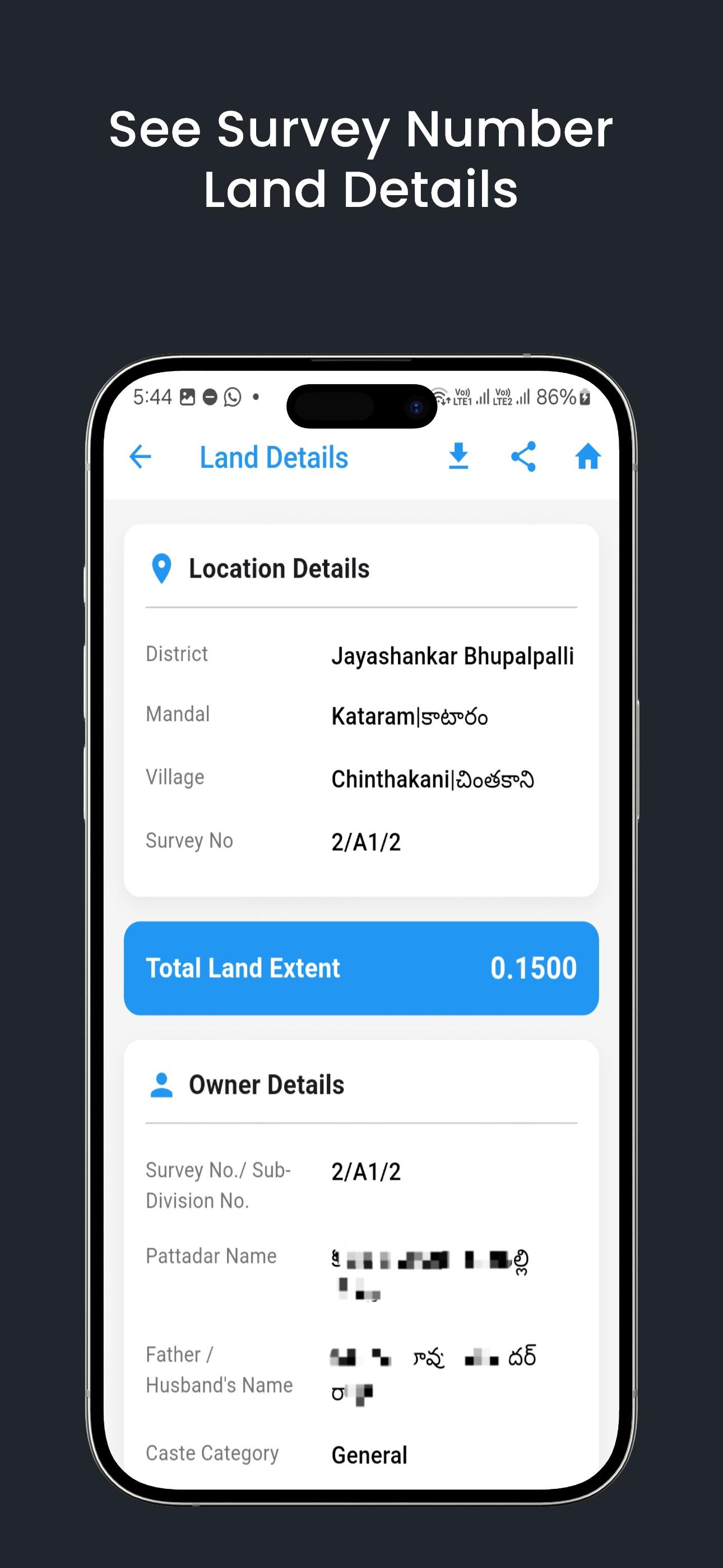
• **Survey Number Search** – Find ROR1B and Pahani details using District, Mandal, Village, Survey No, Khata No, or Pattadar Name.
• **Passbook Lookup** – Instantly fetch records with your land passbook number.
• **Prohibited Lands Info** – Identify restricted lands using location-based search.
• **Cadastral Maps (Telangana)** – View interactive land maps by district, mandal, and village.
• **FMB Maps (Andhra Pradesh)** – Visualize field measurement maps via survey number or village-wide view.
• **Land Measurement Tool** – Accurately measure land using map-based points. Supports units like Acres, Guntha, Hectare, Bigha, Katha, and Square Meters. Generate PDFs with map screenshots and share easily.
---
### 📂 Comprehensive Coverage:
**Telangana Districts:** Adilabad, Bhadradri Kothagudem, Hanmakonda, Hyderabad, Jagtial, Jangoan, Jayashankar Bhupalpalli, Jogulamba Gadwal, Kamareddy, Karimnagar, Khammam, Kumuram Bheem (Asifabad), Mahabubabad, Mahabubnagar, Mancherial, Medak, Medchal-Malkajigiri, Mulug, Nagarkurnool, Nalgonda, Narayanpet, Nirmal, Nizamabad, Peddapalli, Rajanna Sircilla, Rangareddy, Sangareddy, Siddipet, Suryapet, Vikarabad, Wanaparthy, Warangal Rural, Warangal (Urban), Yadadri Bhuvanagiri.
**Andhra Pradesh Districts:** Alluri Sitharama Raju, Anakapalli, Anantapur, Annamayya, Bapatla, Chittoor, Dr.B.R. Ambedkar Konaseema, East Godavari, Eluru, Guntur, Kakinada, Krishna, Kurnool, Nandyala, NTR, Palnadu, Parvathipuram Manyam, Prakasham, SPSR Nellore, Sri Sathya Sai, Srikakulam, Tirupati, Visakhapatnam, Vizianagaram, Westgodavari, YSR.
---
**⚠️ Important Notice:**
Landsnap is an independent application built for user convenience. We do **not represent any government agency**, nor do we offer official government services. All information is retrieved from publicly available data on the official **Mee Bhoomi** and **Bhu Bharati** portals. We encourage users to **cross-verify all data on the official government websites** before making legal or property-related decisions.


One-click to install XAPK/APK files on Android!
Thanks for your rating and feedback!
You have already rated.
